Shallow waters - The Lake of Port Revel
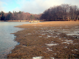
The best way to visualise the shallow waters of the Port Revel lake is to show the lake partly emptied. On this picture, the water level was lowered by about 1 m (25 m at full scale) showing the very extensive shallow water area of "Sogreah Bay" on the SE side of the lake with our "Ras Tanura" platform in the background.
Admire the flat bottom of the lake where anchor-dredging exercises are done in a water depth of 23 m.
Around 50% of the lake consists of shallow waters (< 27.5 m water depth)
Incidentally, we lower the lake's water level as necessary in order to check and/or modify the bottom and banks of the lake.
This is unique in the world of manned models.